When planning your next adventure off the beaten path with limited cell phone reception, the best way to ensure you're on the right track is with a handheld GPS unit.
Today we'll be looking at 5 of the top-ranked handheld GPS units available to purchase in Australia. These units all come from one manufacturer and that is Garmin.
Whether you're looking for the best handheld gps for hunting, hiking, marine, fishing or simply to keep tabs on a loved one, you'll find all the features about each model below.
Best Handheld GPS Australia
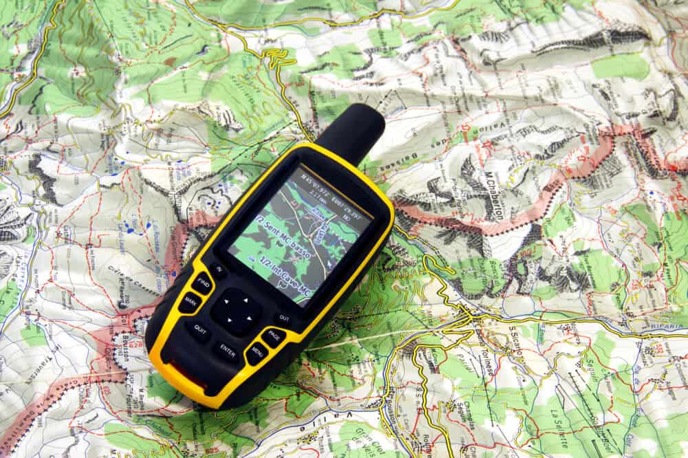
1. Garmin GPSMAP 64 Worldwide

Despite the fact that we now have GPS technology in our cars, phones, even our watches, handheld GPS are still on the market as dedicated outdoor location finders for hikers and others who like to explore the back of beyond due to their superior satellite reception and their durability and rugged build for the outdoor environment.
The Garmin handheld GPS 64 is one such unit.
The Garmin 64 has a rugged water-proof profile with a button-based user interface which can be used in any conditions, even with gloves on or when it’s shaking.
It uses both a rechargeable battery pack as well as conventional replaceable AA batteries, which last up to 16 hours fully charged. It weighs a light 230g with batteries.
The 2.6” sunlight readable colour screen is easy to see in any conditions.
The GPS function is supported by a high-sensitivity GLONASS receiver with a quad helix antenna for better reception and a fast location fix.
The unit is preloaded with a worldwide base map with shaded relief and has an internal memory of 3.5GB and capacity for a microSD card so you have plenty of memory to load additional maps from Garmin GB Discoverer Ordnance Survey 1:25k or 1:50k maps and other supported sources.
You can use waypoints, tracks, and routes to navigate – the Garmin 64 will find your location quickly and hold it even in forests, gullies or on water. Find your way back to base using the TracBack function to guide you safely home.
Garmin’s BaseCamp software allows you to plan future adventures at home on your computer and then transferring the details on to the GPS device.
2. Garmin Montana 610

Garmin is so good at making GPS devices for every situation. They make them for your car, for your wrist and for the rugged outdoors.
Garmin’s Montana 610 handheld GPS locator and tracker is a rugged GPS designed specifically for the outdoor environment away from civilisation and easy markers. It is big, heavy (over 600gms) and very, very tough.
It will perform in the worst possible of conditions – cold, hot, wet, humid, shaky, bumpy, anything. The unit operates on a rechargeable Lithium-ion battery.
With a large 4” dual orientation colour touchscreen that is even glove friendly, the 610 gives you a complete aerial track view so you can see at any time exactly what you’re up against from every direction.
The purchase price includes a 1-year subscription to BirdsEye Satellite Imagery. The unit also includes a 3-axis compass, built-in barometric altimeter and access to both GPS and GLONASS satellites.
The latter provide a very fast fix and better positioning, with the high-sensitivity GPS maintaining your position in the most difficult of locations such as forests or deep gullies.
The Montana 610 comes with 250,000 preloaded geocaches from Geocaching.com, and you can share your favourites with other enthusiasts wirelessly with the 610.
With TrackManager you can organise, navigate and record your way through routes, waypoints and track logs.
3. Garmin ETREX 10

If you’re budget sensitive but want a good reliable but basic handheld GPS the Garmin eTrex 10 may well be the answer for you. At a little under $150 you’re still getting a Garmin, the brand you want if you’re buying a GPS locator.
The eTrex 10 has what you need in an outdoor friendly handheld navigator.
It features a high-sensitivity WAAS-enabled GPS receiver with Hotfix and GLONASS support for a reliable signal and fast positioning.
The unit is waterproof to IPX7 standards (so it will withstand splashes and rain but not full submersion). It has a 2.2” monochrome screen and is loaded with a worldwide base map.
The eTrex 10 is compatible with Garmin Connect so you can join the online community to analyse, categorise and share data.
You can record a favourite route for later use but the internal memory is not large so the ability to store many maps is quite limited.
If what you’re looking for is something to make sure that you can get back home or to your camp then this will suit you just fine. It is not marketed or priced as a GPS with a thousand and one features. It is what it is, and a little bit more.
4. Garmin InReach SE+

Garmin’s InReach SE+ GPS is the top of the line navigator for rugged terrain adventurers who hike, or sail, or climb, or travel outback to the back of beyond.
With both satellite communication and highly accurate GPS capability with high-resolution built-in maps it has all you need to not get lost, and a whole lot more.
The satellite communicator uses 100% global Iridium coverage (that’s a satellite network) so that you can actually communicate using this device.
It gives you a limited ability to message and some interactive SOS capability with worldwide emergency response leader GEOS. What this means of course is that if you get into trouble you can let somebody know and that message will have your location attached to it. Now that is a great feature.
But you do need to have a satellite subscription to have the 2-way texting feature. The SOS search and rescue feature is free, as is the ability to track and share your location with family. There are more features around the tracking and sharing capabilities of the InReach SE+ as well as others like weather forecasting.
The InReach performs all the navigation functions you’d expect including high-detail breadcrumbing for back tracking, a free Earthmate app to pair the unit with your mobile devices to gain unlimited access to TOPO maps, aerial imagery and more.
The unit runs on Lithium-ion rechargeable battery, and the fully charged life is up to 100 hours depending on the mode it’s in. It’s built to be rugged, impact resistant and water resistant. It weighs 522gms.
The InReach SE+ may not have all the features that other handheld GPS navigators carry but the communication capabilities are unique and highly valuable if you truly are going into dangerous territory with a risk of getting lost or hurt.
The ability to contact somebody in that situation is invaluable, and far cheaper than buying a satellite phone!
5. Garmin Alpha 100 GPS

You have to give credit where it’s due, and Garmin certainly deserves credit for the range of handheld GPS devices they have designed for different users. There seems to be a different type for just about every user.
The Alpha 100 is one for the dog lovers amongst us who want something to help track and train their dogs.
Paired up with the special dog collar and other accessories, this GPS gives hunters and trainers the ability to know where their dogs are and how they are performing off the leash at any given time.
The Alpha 100 has a 3” sunlight readable glove friendly touchscreen display.
The unit is preloaded with country specific maps and supports advance mapping like BirdsEye etc. The antenna holds a highly sensitive Quad helix GPS with HotFix intuitive user interface.
It has 3 quick-reference buttons, a 3-axis electronic compass and barometric altimeter. The unit is powered by a rechargeable Lithium-ion battery.
The Alpha 100’s tracking capabilities are great for those of us who have dogs who simply will not be trained to come home.
Dogs love to be off leash and that certainly is the best form of exercise for them but getting lost is no fun. Knowing where they are is a huge relief – not knowing is very worrying! The device is effective from 9 miles away which should be plenty for a normal pooch.
The basic concept underlying the training function is that the dog’s collar has the capacity to deliver different ‘messages’ to the animal depending on how they’re performing to instruction. Instructions are also delivered by the Alpha via the collar.
So the messages are either stimulation (positive or negative) or audible commands. This method of training is so much better than using food as rewards. For one thing you don’t need to be next to the dog to deliver either the command or the reward.
The unit can support up to nine dogs at any given time by purchasing additional collars.
The Alpha is on the pricey side but if you’re serious about your dogs and have a few of them this may well suit you down to the ground, giving you a great method of training and a failsafe way of locating them if they do run after a stray cat (or kangaroo)!
What's a GPS?
GPS stands for Global Position System and it's used to refer to tracking and storing timing and positional data for a wide range of uses. Most of these uses include adventuring into the outback or mountains where cell phone reception is often non existent.
GPS works anywhere in the world regardless of your geographical location. While smartphones require antennas from towers to get signal, GPS sends signals back and forth from satellites, ensuring you always have a GPS co-ordinate.
Often a GPS is intended to work alongside a map or compass and is usually waterproof, rugged and designed to handle any weather system you might experience while out and about.
Budget friendly devices often only track GPS but high end models include features such as being more lightweight, longer battery life and may include cameras or topographic map data.
Do You Need a Handheld GPS?
If you're heading into the thick wilderness then you probably do. Likewise if you're boating in unknown areas, maybe you own a Jet Ski? Or you're heading up a mountain skiing?
However most people probably don't actually need a handheld GPS unit. Ultimately they tell you where you are on a map. You will of course need to download the map before you go, with many models offering access to Geocaching software for downloading local maps.
If you're looking for a call to help device then you want a Personal Locator Beacon. Some models include this feature such as the Garmin InReach SE+ which uses global Irdium Coverage to provide such a service. This allows for two way SMS messaging as well.
Most people have smart phones that actually offer GPS built-in so if you're heading out within cellphone range you probably can make do with your phone. However as a backup, a handheld gps unit can be very beneficial. After all, phones are great when you have signal, not so much if you don't have good signal though!
What To Consider When Buying Handheld GPS?
There's a few factors to consider when you start to decide to purchase a handheld GPS. On most people's minds is the weight of the device as you'll have to carry this in your backpack or on your person. Thankfully most devices are very lightweight, weighing 200-500 grams.
Next you'll want to consider how large a screen you want to have? Most are small screened, with bigger screens often having touch-screen capabilities.
All GPS devices include screens that are readable under direct sunlight.
Some guides mention touch-screen devices respond better to buttons but I have to disagree. The good old button is far more reliable than touch-screen which can stop working if you have moisture on your hands or are wearing gloves!
Reception Quality
Nearly all modern day handheld gps units are incredibly accurate, pinpointing your location within 10-15 meters. It's quite unbelievable, especially if you're new to technology.
More advanced devices that use WAAS (Wide Area Augmentation System) often provide better accuracy such as within 3 meters. Of all the devices we featured today, they all include WAAS which ensures you get the best accuracy. For relevancy most modern smartphones offer accuracy within a radius of 5 meters.
Of all the devices featured today the Garmin GPS MAP 64s offered the best reception rating with the ETREX 10 coming in a close second.
To get a better reception you should ensure your device includes a high-sensitivity GLOBASS receiver with a quad antenna. While some models don't offer the quad helix antenna, those that do offer better reception and faster locations.
Maps - How They Work?
One of the main things to note when buying a gps device is that you won't have fully fledged maps like you might expect on your latest smartphone. Maps on GPS devices are pretty basic to start with, you'll see roads, rivers and that's about it.
Most devices allow you to buy a GPS map after you've bought the initial unit. These usually require additional subscriptions or download fees to get the best maps. Additionally you can use free resources to download maps, i.e. some hiking sites have maps for certain locations.
Most maps cost a few hundred dollars per year to access them. It's important to note you'll need to factor this in if the standard maps are insufficient for your needs.
Some units include free access to maps databases.
Geocaching
Geocashing is a fairly new outdoor activity that is enjoyed by enthusiasts around the world. By using a GPS device you can look for hidden treasures around the world. Some of the more impressive handself gps units offer built-in geocaching features.
How Do GPS Units Work?
GPS units sound complex but actually have a simple design and operational method that communicates with satellites orbiting earth. These signals read and triangulate signals sent from your GPS unit. After contacting at least four different satellites it is able to pinpoint your position with a certain degree of accuracy such as 10 meters.
No matter where you are in the world, your GPS device can connect to these satellites (for free) and provide an accurate GPS location. Usually these are provided by the USA, Russia and European Union that control a vast network of satellites.
Verdict
If you're looking for the best handheld gps Australia has to offer then you can do no wrong with any of the Garmin models mentioned above. For an all rounder then you should consider the Garmin GPSMAP64. If you're working with animals then the Alpha 100 is another smart device.

- 6+ Best Cisco CCNA Courses Online In Australia - May 21, 2022
- 6+ Best OBD2 Scanners In Australia For Your Car - May 21, 2022
- 5+ Best Camping Lanterns For Your Next Trip Away - November 30, 2021
This post contains affiliate links. As an Amazon Associate I earn from qualifying purchases. If you click a link and make a purchase, I may receive a small commission at no extra cost to you.
Last Updated: December 2, 2021 by Rhys